Summary
At present, China's conventional power line inspection work is mainly carried out by means of manual inspection and aerial photography of aerial lighting. The former inspection personnel have a large amount of labor, low work efficiency and reliability, and some unmanned area personnel cannot reach; the latter Although it is photoelectric inspection, the data accuracy is low, and it is impossible to accurately measure the safety distance between the line body and the offline object, and the data utilization rate is low. With the development of photoelectric measurement and electronic information technology, laser radar has emerged as a new type of photoelectric measurement equipment. The emergence of laser radar provides a feasible solution for power inspection. With the construction of China's EHV transmission lines and smart grids, airborne LiDAR will be widely used in power grid engineering.
The power grid is a project that spans large areas. From the planning, surveying, design, construction, operation, management, maintenance, marketing, and decision analysis of power grids, there is a strong demand for regional spatial information. Laser LIDAR measurement technology provides spatial data support for the refined, scientific and efficient grid design and management due to its high precision and full three-dimensional characteristics.
Transmission lines are the most important part of the power grid, and the terrain, landforms and features of the line corridors have a major impact on the construction and safe operation of the lines, and are the areas of greatest concern for line design and management. At present, the spatial data collection methods of power line corridors mainly include manual mapping, aerial survey and remote sensing, and laser LIDAR measurement technology can quickly perform high-precision three-dimensional measurement on the line corridor, thus designing, operating, maintaining and managing enterprises and professions for transmission lines. People provide faster, more efficient and more scientific means. Laser LIDAR
The measurement system can directly collect high-precision laser point cloud and high-resolution aerial digital image of the line corridor, thereby obtaining high-precision three-dimensional line corridor topography, line facilities and equipment, as well as precise three-dimensional information of corridor objects, including towers and hanging Line position, wire sag, trees, buildings, etc., to provide high-precision measurement data for power line planning, design, operation and maintenance. The following figure shows the application of laser LIDAR measurement technology in power grid engineering.
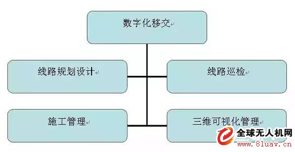
The overall idea of ​​the onboard LiDAR grid application
In the line design stage, the transmission line needs to perform high-precision three-dimensional measurement within a certain width of the initially selected line corridor to optimize the line path and tower positioning, so as to minimize the construction investment. Aerial photography is used in the construction drawing design phase for transmission lines and some high-voltage lines. Aerial photogrammetry is a big breakthrough compared with engineering survey, but there are still problems such as low line section accuracy, large field workload, unintuitive data, and difficult software platform.
Lidar measurement technology High-efficiency acquisition of line corridor 3D data with high precision, rich information, convenient data use, and can greatly reduce the workload of the field, improve the design efficiency and quality of results, and the application of this technology can greatly save the design The cost of surveying, shortening the operating cycle, making the design more reasonable, and quickly enabling complex power and grid information to be networked and visually managed can produce good economic and social benefits.
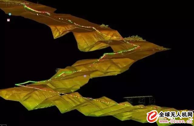
Diagram transmission line optimization design
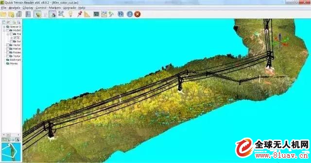
Figure Scanning effect of dense vegetation corridor
At present, China's conventional power line inspection work is mainly carried out by means of manual inspection and aerial photography of aerial lighting. The former inspection personnel have a large amount of labor, low work efficiency and reliability, and some unmanned area personnel cannot reach; the latter Although it is photoelectric inspection, the data accuracy is low, and it is impossible to accurately measure the safety distance between the line body and the offline object, and the data utilization rate is low. With the development of photoelectric measurement and electronic information technology, laser radar has emerged as a new type of photoelectric measurement equipment. The emergence of laser radar provides a feasible solution for power inspection. With the construction of China's EHV transmission lines and smart grids, airborne LiDAR will be widely used in power grid engineering.
General idea of ​​airborne LiDAR system in power grid engineering application
The power grid is a project that spans large areas. From the planning, surveying, design, construction, operation, management, maintenance, marketing, and decision analysis of power grids, there is a strong demand for regional spatial information. Laser LIDAR measurement technology provides spatial data support for the refined, scientific and efficient grid design and management due to its high precision and full three-dimensional characteristics.
Transmission lines are the most important part of the power grid, and the terrain, landforms and features of the line corridors have a major impact on the construction and safe operation of the lines, and are the areas of greatest concern for line design and management. At present, the spatial data collection methods of power line corridors mainly include manual mapping, aerial survey and remote sensing, and laser LIDAR measurement technology can quickly perform high-precision three-dimensional measurement on the line corridor, thus designing, operating, maintaining and managing enterprises and professions for transmission lines. People provide faster, more efficient and more scientific means. Laser LIDAR
The measurement system can directly collect high-precision laser point cloud and high-resolution aerial digital image of the line corridor, thereby obtaining high-precision three-dimensional line corridor topography, line facilities and equipment, as well as precise three-dimensional information of corridor objects, including towers and hanging Line position, wire sag, trees, buildings, etc., to provide high-precision measurement data for power line planning, design, operation and maintenance. The following figure shows the application of laser LIDAR measurement technology in power grid engineering.
The overall idea of ​​the onboard LiDAR grid application
Application of Airborne LiDAR in Optimum Design of Transmission Lines
In the line design stage, the transmission line needs to perform high-precision three-dimensional measurement within a certain width of the initially selected line corridor to optimize the line path and tower positioning, so as to minimize the construction investment. Aerial photography is used in the construction drawing design phase for transmission lines and some high-voltage lines. Aerial photogrammetry is a big breakthrough compared with engineering survey, but there are still problems such as low line section accuracy, large field workload, unintuitive data, and difficult software platform.
Lidar measurement technology High-efficiency acquisition of line corridor 3D data with high precision, rich information, convenient data use, and can greatly reduce the workload of the field, improve the design efficiency and quality of results, and the application of this technology can greatly save the design The cost of surveying, shortening the operating cycle, making the design more reasonable, and quickly enabling complex power and grid information to be networked and visually managed can produce good economic and social benefits.
Diagram transmission line optimization design
Figure Scanning effect of dense vegetation corridor
We are manufacturer of 510 Thread Cartridge in China, if you want to buy Battery Pen 510,Rechargeable Cbd Battery,Adjustable Voltage 510 Battery please contact us.
510 Thread Cartridge,Battery Pen 510,Rechargeable Cbd Battery,Adjustable Voltage 510 Battery
ALD GROUP LIMITED , https://www.aldvapor.com